Solutions
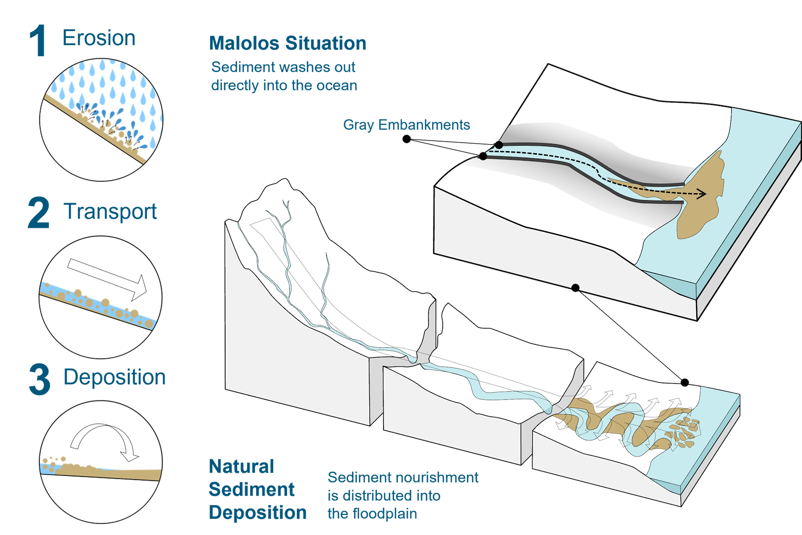
Flooding can cause significant disruptions and damages to human infrastructure; however, it is a natural process vital to many ecosystems. Floodwaters carry sediments – particles like sand, silt, and clay across various landscapes. When floodwaters slow down or recede, they deposit these sediments on floodplains, riverbanks, and deltas as illustrated in the figure below. Over time, these sediments build up, creating fertile soils that support agriculture and vegetation. However, in urban areas in the City of Malolos where floodplains are utilized for human activities, the sedimentation process can be disrupted and be challenging to restore to its natural state. Alterations to natural drainage patterns and construction on floodplains can disrupt these natural processes and lead to subsidence and increased flooding, which is the current reality of the residents in the area.
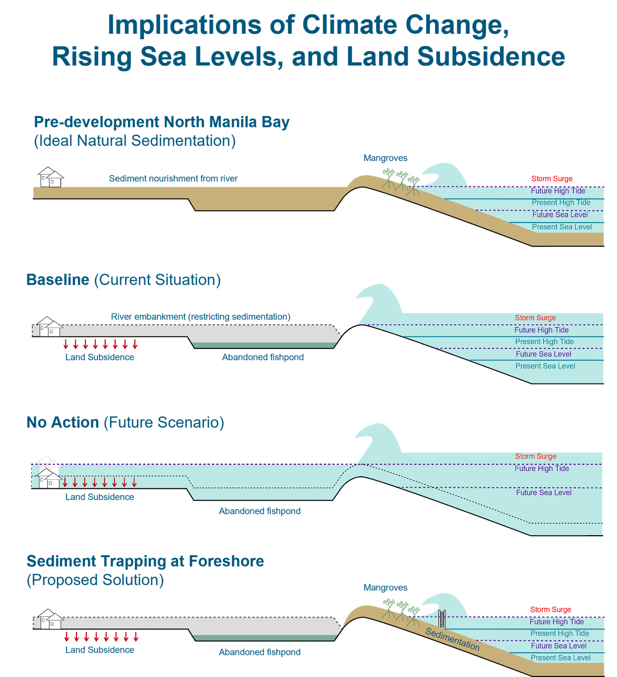
The initial site assessments also reveal that the worsening floods in the City of Malolos are highly influenced by compounding factors such as climate change, rising sea levels, unchecked land subsidence, and storm surges at the coastal regions as illustrated in the figure below. Majority of the waterways have been lined up with dikes, restricting natural sedimentation and exacerbating ongoing land subsidence. In addition to that, multiple inhabitants already encroach upon the rivers potentially disrupting its ecological balance and risking their own safety. Moreover, mangrove forests which act as natural barriers for storm surges, have been converted into fishponds – most of which have been abandoned due to low production yields. These factors, combined with the implications of climate change and rising sea levels, could result in the submergence of the low-lying areas in City of Malolos, especially the coastal regions if a business-as-usual setting continues. In connection to the previous section, as an initial step towards enhancing flood resilience, the NbS pilots are proposed in two (2) locations, namely Brgy. Bagna-Panasahan and Brgy. Pamarawan.
The proposed intervention for Brgys. Bagna-Panasahan depicted in this figure, includes the implementation of a green embankment connecting to the ongoing DPWH seawall to close the barrier for flood protection. It also provides an opportunity to complement the existing traditional structures with a nature-based approach. However, it is important to note that this development is constrained by the available land space and is planned to avoid displacing households that have encroached upon the riverbanks.
As for Brgy. Pamarawan, the proposed NbS interventions include mangrove reforestation, sediment trapping, green embankment, and enhanced breakwaters as illustrated in this figure. The figure also presents that these NbS measures can complement SMC’s proposed mudflat restoration as introduced in the previous chapter.
Overall, these proposed pilot projects serve as an initial step towards promoting replicability in future locations (e.g., natural sedimentation processes), aiming for a more integrated approach to flood resilience. Moreover, it is highlighted that the pilots are earmarked to complement existing and planned DPWH interventions and private initiatives. This aligns with one of the goals of the pilots to prove that Nature-based Solutions are a feasible alternative to existing common practices in the Philippines.