Results from Site Visits and Household Surveys
A series of household surveys and site visits were performed in the target barangays in the city (i.e., Barangays Atlag, Bagna, Santo Rosario, and Pamarawan). The goal of the survey was to assess the residents’ demographics, livelihood, exposure to hazards, perceptions to risks, and provide additional inputs on the Nature-based Solutions criteria in prioritizing pilot locations in the City of Malolos. The data gathering procedure involved the LGUs and various stakeholders to jointly assess the ongoing situation of the barangays. The following data were then analysed from the survey forms and are presented in the following subsections.
Demographics
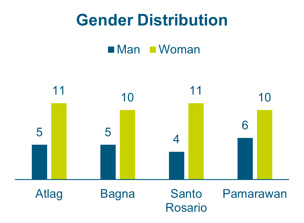
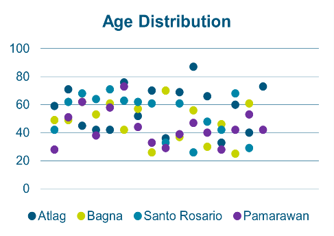
At least 15 interviews were done per barangay (i.e., Barangay Atlag [16], Barangay Bagna [15], Barangay Santo Rosario [15], Barangay Pamarawan [16]) and majority of interviewees were women (68%) of the respondents as shown in the figure below. In addition, the average age of the interviewees falls under the age bracket of 40 to 60 years old; the youngest being 25 years old and the oldest is 87 years old. The distribution of age helped to ensure reliability of gathered data that involve long-term residents that are of legal age, who are aware of their environment.
Demographics
Livelihood
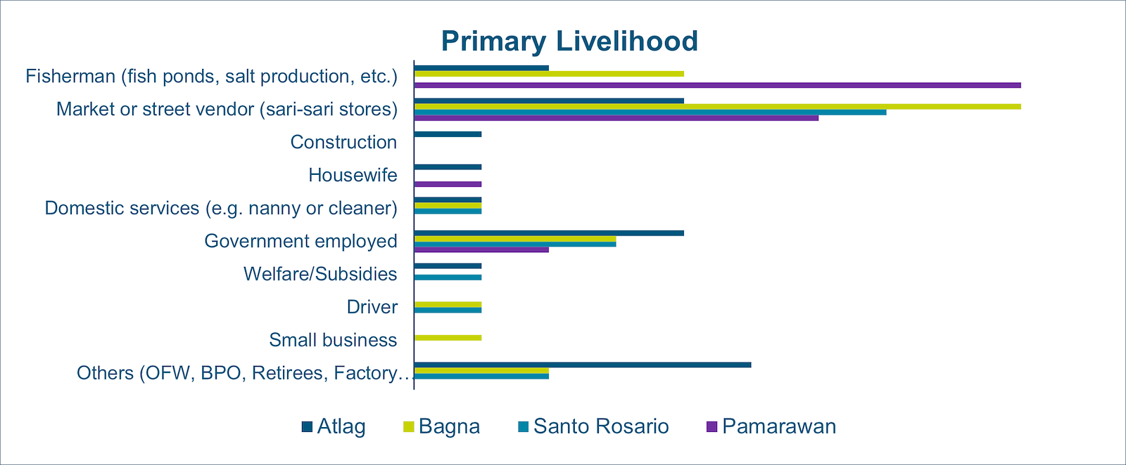
Among the respondents, the figure below showed that cumulatively the primary livelihood in the barangays is aquacultural activities with Brgy. Pamarawan with the greatest number of respondents whose livelihood is associated with the fishponds, baklads, oysters, and salt production. Other primary livelihood activities involve micro enterprises in the markets and convenience stores. Other respondents are also employed in the government and private sector, especially those situated in Barangay Atlag, an urban barangay.
During the survey, photos were captured as shown below that depict the diverse livelihood opportunities despite the natural hazards in the different barangays in the city of Malolos.
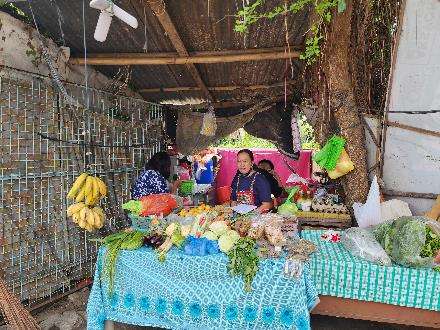 | 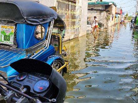 |
Local vegetable vendor in Brgy. Atlag | Tricycle driver traversing ankle-level flood |
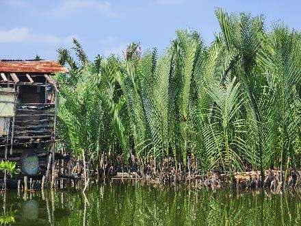 | 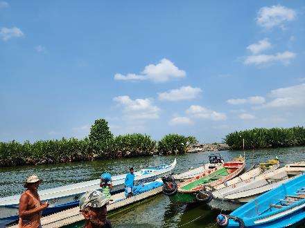 |
Nipa palms (sasa) as local source of vinegar | Fisherfolk in Panasahan Fish Port |
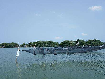 | 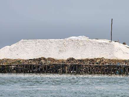 |
Fishing nets (baklads) towards Brgy. Pamarawan | Salt production along Calero River |
Exposure to Water-related Hazards

To further identify the primary causes of flooding based on the respondents’ perceptions, each barangay was assessed based on their exposure to water-related hazards and the results are presented in the figure to the left. As shown in the figure, the residents of Malolos mainly (are perceived to) suffer from combined flooding hazards and continue to experience the exacerbated effects throughout the years. Majority of Barangay Atlag respondents, mainly encounter flooding from the adjacent river and is caused by a combination of factors such as high-tides, heavy rainfall, poor drainage systems, and release of water from the dam during storm events.
Since Barangay Bagna is right next to Atlag, the residents also experience the same flood hazards from the neighboring waterway, and is caused by a combination of heavy rainfall, poor drainage systems, release of water from the dam, and mainly, the effect of sea-level rise or high tides. Respondents also expressed their concerns of unequal opportunities in road and property elevations as underdeveloped areas become water impoundments overtime.
Barangay Santo Rosario is another inland barangay surrounded by tributary creeks and rivers which are the main flood hazard of the locality. Factors such as heavy rainfall, release of water from the dam, and high tides or sea-level rise primarily contributes to flooding. Residents in the barangay mention that they have elevated their properties multiple times already to mitigate the current hazard but are still concerned of land subsidence.
Barangay Pamarawan, on the other hand, is a small island barangay separated from the mainland therefore exposing it to coastal hazards primarily caused by storm surges and high tides. Residents continue to refer to the airport development’s negative impacts towards flooding and the environment, including the project-related ocean bed dredging done for ship operations which aggravated the island’s tidal conditions and loss of fish stock.
Overall, these hazards show interconnected influences which could be addressed through an integrated approach with the incorporation Nature-based Solutions.
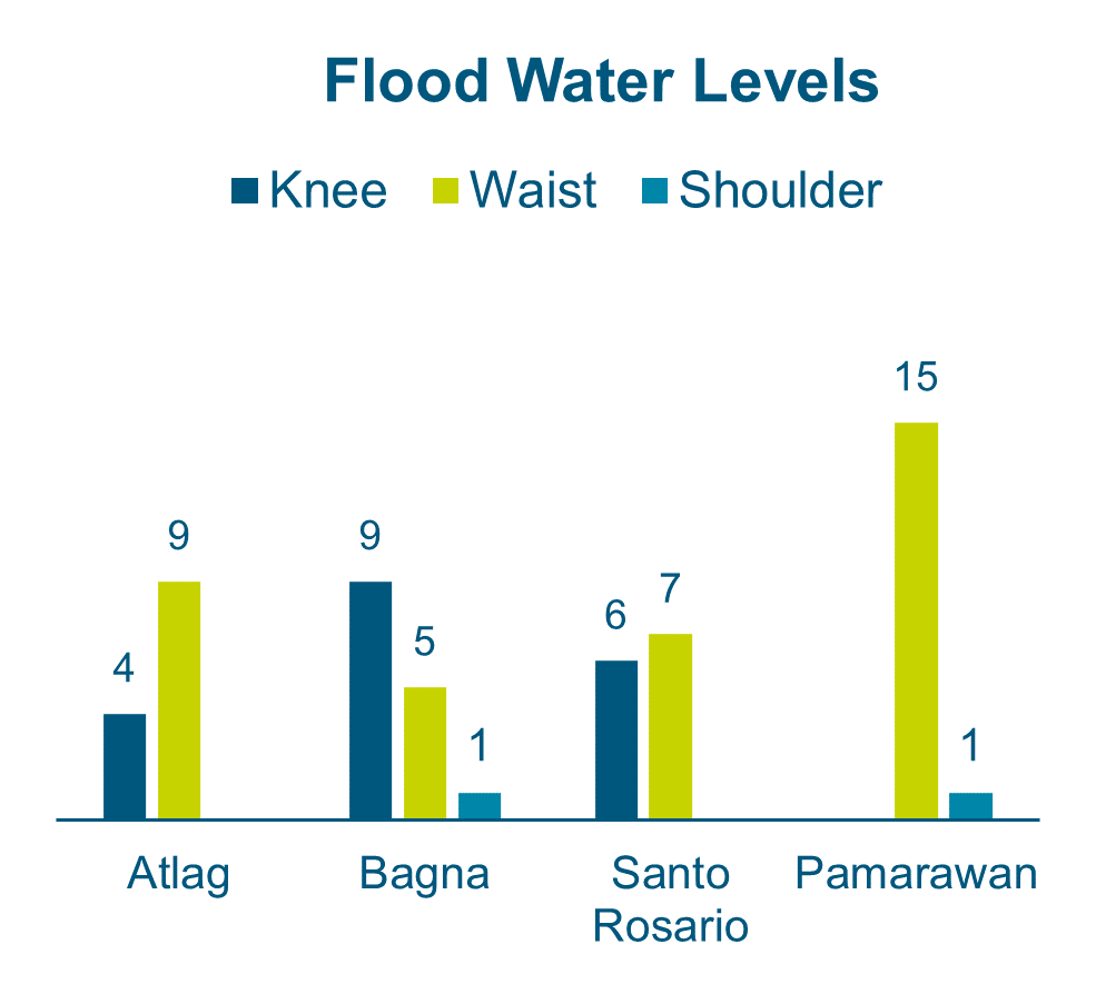
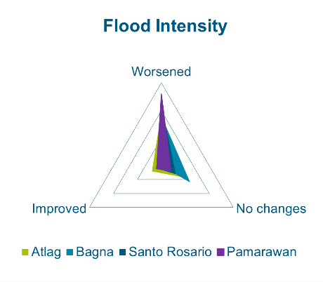
Flood Water Levels and Flood intensity
During typhoons, flooding usually ranges from the knees to waist-level for inland barangays as depicted in the figure above with one interviewee from Barangay Bagna mentioning a shoulder-level flood occurrence during an extreme storm event. However, respondents from Barangay Pamarawan covers most waist-level floods, which can also reach up to the shoulders during extreme events. As for the changes in flood intensity in the figure above, most of the respondents shared that they have noticed aggravated conditions throughout the years, some of them mentioning the onset of the airport development as a reference point for said changes. Notably in Barangay Pamarawan, where tidal flooding is a regular occurrence, residents are growing more concerned about the deviations in water levels as 3.6-foot tides now unusually overflows into the barangay, which was not the case before.
Flood-related Damages
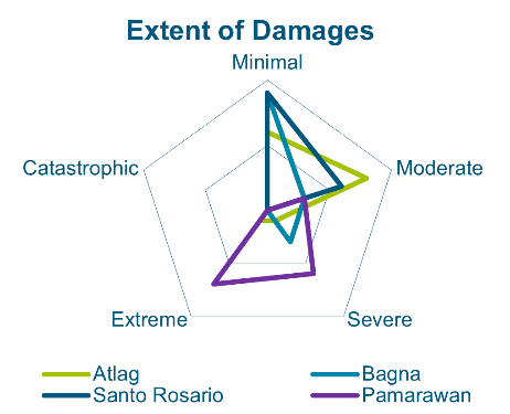
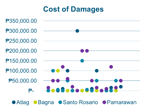
As for the impacts of these flooding, the inland barangays experience minimal to moderate damages as shown in the figure. Only Barangay Pamarawan had results from respondents ranging from severe to extreme damages as an effect of the storm surges during typhoon events; and may reach costs up to PhP 200,000 for rebuilding devastated households as depicted in the figure below. One respondent in Barangay Santo Rosario estimated an amount of PhP300,000 to restore and elevate their property to accommodate the worsening floods. Primarily, the urban barangays which experienced minimal damages estimate around PhP10,000 to PhP50,00 for reparation costs to more extensive renovations.
 |  |
Flood related damages | |
Perceptions on Nature-based Solutions
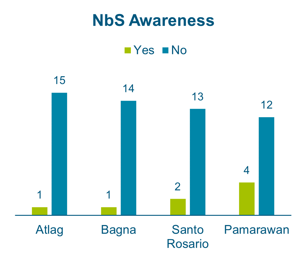
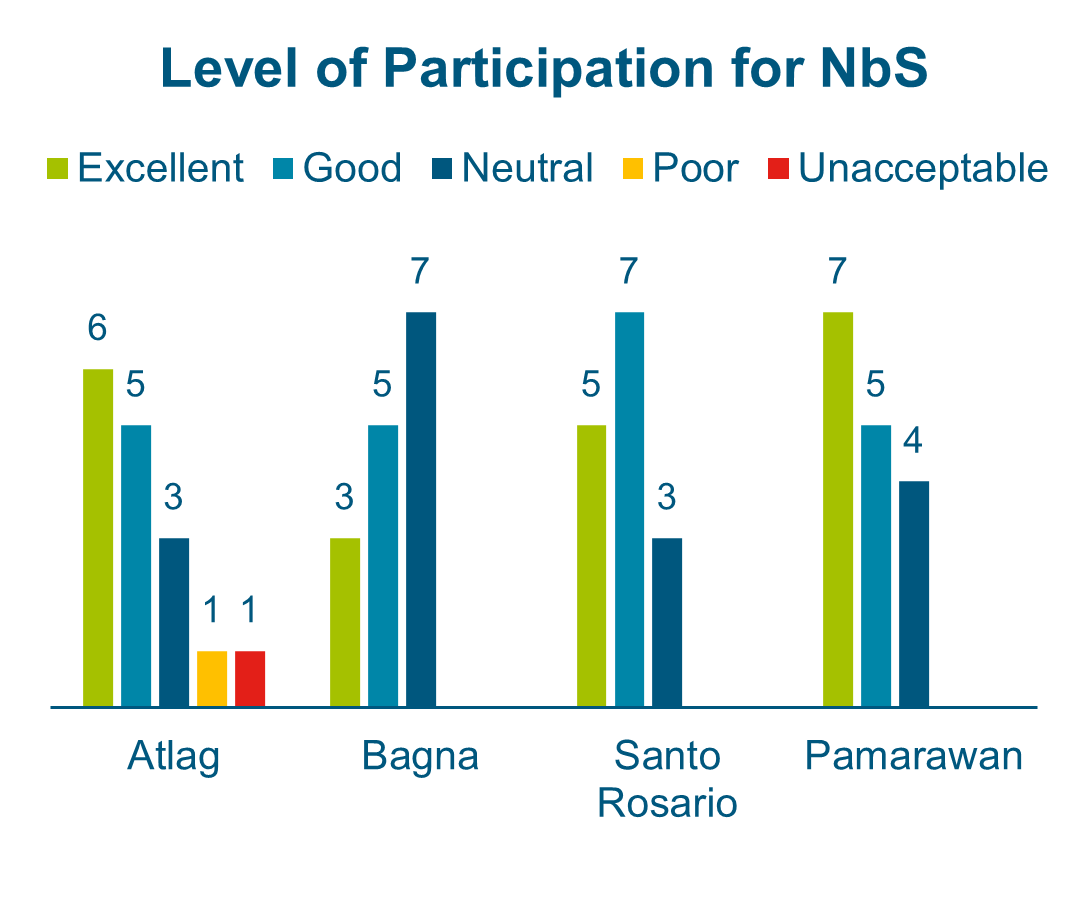
After the brief introduction of the Nature-based Solutions among the respondents, Figure 4‑12 shows that most are unaware of them, and those who are, cited mangrove planting as an example. After learning more about building with nature, the residents were then assessed regarding their level of support and participation for said solutions with the results summarized in Figure 4‑12. The respondents noted that about 80% of the respondents noted their positive response on their level of support for the Nature-based Solutions project implementation. On the other hand, four percent (4%) of the negative responses came from Barangay Atlag respondents stating disbelief in the effectiveness of Nature-based Solutions to the urban environment and would rather prefer hard engineering interventions for their barangay.
 |  |
Perception of Nature-based Solutions | |
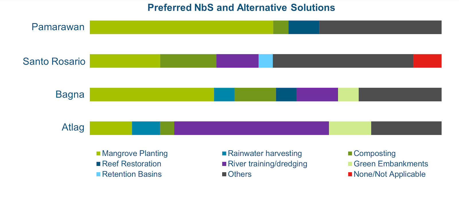
Specifically, the respondents were asked for their inputs regarding their preferred Nature-based Solutions or alternative solutions to be implemented in their respective communities. As shown in Figure 4‑13, each type of solution differs per barangay depending on their perceived compatibility. The “Others” option included by the respondents include:
-
Planting more trees
-
Constructing dikes
-
Elevating roads/properties
-
Improving drainage systems and waste management
-
Implementing education and livelihood programs and projects
For example, residents of Barangay Pamarawan are more in favor of mangrove planting, which they see to be effective based on current community-led actions. In addition, they also perceive reef restoration as beneficial to their oyster production. Majority of the inland barangays would prefer river training works and dredging as the main solution to their flooding problems especially in Barangay Atlag. Also, it is noted that Barangay Atlag and Bagna are interested in the setting up of green embankments. Nevertheless, some residents in Barangay Santo Rosario still believe that Nature-based Solutions is unsuitable for their barangay due to its urbanized condition, thus, the lack of space to implement such interventions.
