SUMMARY
In the next 40 years, it is expected that the urban area in the catchment of Manila Bay will roughly have doubled, with an increase of population from 33 million people in 2015 to about 51 million people by 2050. This requires the greatest attention of the Government of the Philippines in order to adequately regulate the spatial and master plans. In response to the need for a comprehensive plan for Manila Bay, the National Economic and Development Authority (NEDA) initiated in 2018 the formulation of the Manila Bay Sustainable Development Masterplan(MBSDM). The Government of the Philippines (through NEDA) and the Government of the Kingdom of Netherlands (through the Ministry of Foreign Affairs) completed the Manila Bay Sustainable Development Masterplan by the end of 2021.
One of the priority measures of the Manila Bay Sustainable Development Masterplan is to drastically reduce people, properties, and livelihood exposure to flooding, especially informal settler families in hazard-prone areas, by establishing a coastal line of defense (CLD), relocating residents in extreme-subsiding barangays (i.e., seaward of the CLD) and implementing nature-based coastal protection programmes.
The coastal line of defense is proposed in the Manila Bay Sustainable Development Masterplan to provide flood protection for the areas north of it. The alignment of the coastal line of defense more or less follows the historical coastline of the north manila bay area.
Project Strategy
Based on the Manila Bay Sustainable Development Masterplan the Netherlands Enterprise Agency identified increased exposure to flooding as one of the major issues and threats to the development of Manila Bay in the coming 50 years, particularly in the northern coastal area. Therefore, the Netherlands Enterprise Agency requested for proposals to develop the North Manila Bay Flood Protection Strategy in August 2021; Royal HaskoningDHV was awarded the strategy and have completed it by February of 2022
The goal of the North Manila Bay Flood Protection Strategy is:
"To develop a Flood Protection Strategy which identifies sustainable, nature-based flood protection measures for the Northern Manila Bay coastal area, and to recommend pilot locations for implementation of these measures."
With this goal, the North Manila Bay Flood Protection Strategy gives substance to one of the priority measures of the Manila Bay Sustainable Development Masterplan: to "Reduce Exposure in Flooding", action: "REF003 | Design and Implement Nature-Based Flood Protection Solutions" [1]. The designed and implemented project can be an example and catalyst for further implementation of Nature-based Solutions.
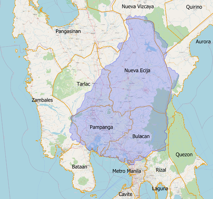
The physical scope of the strategy is focussed on the area surrounding and south of the coastal line of defence in the Provinces of Bulacan and Pampanga. The strategy also provides Nature-based Solutions(NbS) north of the coastline of defence to reduce fluvial flooding. It identifies Nature-based Solutions that can be implemented along the coastal line of defence, and it provides a wide array of Nature-based Solutions to protect the people who live outside of the coastline of defence, in the North Manila Bay area.
For the past decade, up to the present day, North Manila Bay Delta is and has been part of various research studies. Amongst which are the Manila Bay Sustainable Development Masterplan and the Landscape Proposition for North Manila Bay by Wetlands International. The area also harbours several major construction projects such as the New Manila International airport, river training schemes and dredging projects. The North Manila Bay Flood Protection Strategy considers the various components, interests, ideas, and opportunities this collection of interfaces presents. This strategy provides an overview and gives a snapshot of the vast amount of information and data currently available on the subjects discussed. However, overlap and conflicting interests of these interfaces remain a point of attention in the years to come.
Root Cause Analysis
This North Manila Bay Flood Protection Strategy’s foundation is a root cause analysis into the flooding problems. The following root causes are identified:
Delta characteristics
The North Manila Bay area is a river delta. River deltas are naturally low-lying areas formed by a balance between the accretion and erosion of sediment. This natural character of the area increases its proneness to flooding.

Population expansion
The historic coastline of the North Manila Bay Delta lies north of several of the current population centres. It is estimated that 300,000 people live seaward of the historic coastline. The population growth models show that the population north of Metro Manila will increase for the coming decades, especially in the Bulacan and Pampanga areas

The decline of natural habitat
The North Manila Bay Delta used to have large mangrove and tidal flat areas that would act as natural flood defence. Mangroves and tidal flats capture the sediments coming from the rivers upstream, allowing them to grow together with water level changes. This natural habitat has been removed due to human activity. With the natural habitat gone, the ability of the North Manila Bay natural defence system to reduce disasters with rising sea level and subsiding ground level has also been substantially reduced.

Storm Surges
Storm surge heights are significant. Studies on hindcast data and data collected from the site visits show that water level elevations (storm surges) have reached up to 2 meters above Mean Sea Level (MSL) during severe typhoons. From a statistic perspective, surges up to 3 to 4 meters are possible during more rare events.

Erosion and sediment shortage
Due to the loss of mangrove areas and river canalization, the North Manila Bay Delta holds much fewer natural sediments than 70 years ago. The sediments acted as a natural flood barrier and ecological habitat.

Climate change
The most conservative emission scenarios show 0.9 m of plain sea level rise can be expected within the next 50 years. If plans for reducing carbon emissions worldwide are adopted to have the most optimistic effect, 0.6 m of plain sea level rise can still be expected.

Fluvial flooding
The progressing cultivation of the mangrove areas and conversion of tidal flats adjacent to rivers, the canalization of the rivers, and restrictions of the natural river flow in the form of narrow dikes and fishpond expansion have reduced the discharge and storage capacity of the river systems.

Local rainfall
Road and riverbank elevation (to compensate for subsidence) without proper adjustments of the local drainage systems has led to water clogging in many places within the study area.

Land subsidence
Land subsidence resulting from excessive extraction of groundwater has caused a significant lowering of land levels in wide parts of the North Manila Bay Delta, up to an average of 0.05 m per year. At this moment, land subsidence in many areas is contributing to flooding much more than the sea level rise

Sediment extraction
There are several existing mining concessions close to the North Manila Bay Delta coastline and within the rivers. These concessions entail the extraction of marine and river sand, aggregates and other minerals. When these areas are mined, the seabed will transform (will become deeper), leading to a disturbance of the current morphological layout of the North Manila Bay Delta, with a risk of increasing flood exposure.

Institutional and organisational setup
Stakeholder consultations showed that the Local Government Units (LGU) are aware of the problems and deal with the impacts of flooding on a day-to-day basis. Existing legislation within the Philippines offers tracks for support and funding of solutions for these vulnerable LGUs but in practice, the LGUs do not have the resources to organize and plan for tapping into national government resources. It has been observed that in most flood protection works, the focus is on the capital expenditure costs (CAPEX) and not so much on the life cycle costs of a project, which is one of the key benefits/drivers for Nature-based Solutions.
The North Manila Bay Flood Protection Strategy sees the decline of natural habitat, erosion and sediment shortage, sediment extraction and the institutional setup as endogen which proactive measures can change. The other root causes are exogen and require reactive measures as a solution.
Given these root causes, Nature-based Solutions seem to be a perfect fit to resolve some of the causes for the flooding problems. Nature-based Solutions address infrastructural needs, offer protection from climate impacts and act as hazard mitigation tools while they contribute to restoring eco-system benefits and biodiversity.
Stakeholders and Institutions
The stakeholder engagement of this strategy aims to engage the stakeholders in a meaningful way, considering their aspirations, sentiments, and recommendations at different project stages.
“Nature-based Solutions are actions to protect, sustainably manage, and restore natural and modified ecosystems that address societal challenges effectively and adaptively, simultaneously providing human well-being and biodiversity benefits.”

It is based on the belief that people and entities affected by the North Manila Bay Flood Protection Strategy have a right to be involved in the decision-making process. By recognizing, communicating, and reflecting the interests and needs of the different stakeholders, sustainable decisions may be ensured. A total of approximately 50 meetings/workshops were held to collect input and opinions spread over 20 different stakeholders. The results showed a complex situation for the North Manila Bay Delta in which large-scale economic developments and ongoing cultivation of lands pressure the restoration options and protection of natural habitats and ecosystems. However, there also is widespread understanding and willingness to act now on flood protection and habitat restoration to prevent more disasters in the future.
The North Manila Bay Flood Protection Strategy team has conducted 8 (day) site visits in which local officials were visited, and workshops were held as part of the stakeholder involvement efforts. Several barangays and rural areas in the North Manila Bay Delta were visited. During the site visits, approximately 80 household surveys were held to acquire data on how local residents perceive the impact of flooding and the main causes and solutions for it. Results of these household surveys are available via the online iReport website of the strategy. As part of the site visits, aerial footages (drone imagery) were collected, which are also available via the online iReport.
Analysing and identifying the right institutional setting is pivotal for both the wider strategy's success and proposed pilot projects. There are current institutional and regulatory frameworks in place which could provide a foundation for implementation, amongst which are the Integrated Coastal Management (ICM) policies, the Manila Bay clean-up (AO-16) and assistance for developing LGU’s. Through various meetings and workshops, an approach was developed for both the strategy and the proposed pilot location that uses the existing institutional and regulatory frameworks while also adding guidance on implementation improvements. For the pilot projects especially, that will mean that the 2022 elections need to be awaited before any further action can be undertaken. After the elections, either the ABB-BP (organisation of unified LGUs in North Manila Bay) or a supportive LGU will need to request external funding to acquire resourcing support. Once the resources are available, the ABB-BP or LGU can start developing their Comprehensive Land Use Plans to include this strategy and in parallel request for funding of the pilot projects under the ICM framework. Besides this direct setup and funding approach, the North Manila Bay Flood Protection Strategy offers other setups or funding approaches that might be needed for the ABB-BP/LGU in developing the proposed pilot projects.
Location Selection
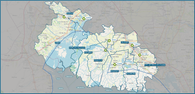
The geographical scope of the North Manila Bay Flood Protection Strategy covers the provinces of Bulacan and Pampanga; it is assumed that the strategy will need to be implemented in so-called “priority areas”. This strategy identifies the following priority areas:
Population centres and areas south of (towards Manila Bay) the Coastal Line of Defence
For the smaller population centres near Manila Bay, the strategy provides small scale Nature-based Solutions that help the inhabitants resilience against flooding in the short-term. But in line with the Manila Bay Sustainable Development Masterplan the aim is to motivate inhabitants to move/relocate more inland, as due to sea-level rise and land subsidence, the area is not suited and sustainable for further urban development. New infrastructure developments will need to be discouraged while nature-based flood protection will be provided following the principles for the restoration of the coastal intertidal system. Nature-based Solutions will be focussed on measures that have a direct positive effect on the safety, livelihoods and sustainability of the living environment (ecosystems, natural resources and biodiversity) as these are interconnected.
Population centres along (north of) the Coastal Line of Defence
Apart from population centres, livelihoods and infrastructures are also vital for the people who live outside(north) of the CLD. The Manila Bay Sustainable Development Masterplan envisions that future development and population growth will take place north of the Coast Line of Defence and attention being paid to people that have chosen to relocate from the areas south of the CLD.
Infrastructure and livelihood
Nature-based Solutions on each side of the CLD are focussed on contributions towards transforming relevant livelihoods towards more sustainable and inclusive (future proof) alternatives linked to reduced flood risk along coast and rivers, and around priority population centres.
This strategy maps out these priority areas and assesses them on their exposure to the various flood related criteria. Combining this with the assessment of the 20 potential Nature-based Solutions will provide a canvas/matrix that can be used to prioritize certain projects and locations.
Based on this strategy, several maps have been developed, of which the Nature-based Solutions overview map shows what the full implementation of the strategy would look like. The map is the result of the work done in this strategy inspired by the Ecoshape/Wetlands International’s proportion to DENR for the same areas and tries to balance the plans and interests of the Manila Bay Sustainable Development Masterplan, the landscape proposition by Ecoshape/Wetlands International and opinions and ideas collected during the stakeholder meetings.
Pilot Locations
It has been identified by the Netherlands Enterprise Agency that pilots projects are needed to promote and show the feasibility of Nature-based Solutions. The North Manila Bay Flood Protection Strategy identifies pilot locations as an opportunity to serve as a catalyst for implementing the strategy and Nature-based Solutions in the Philippines as a whole. Two pilot locations have been identified:
Green embankments in Masantol and Macabebe
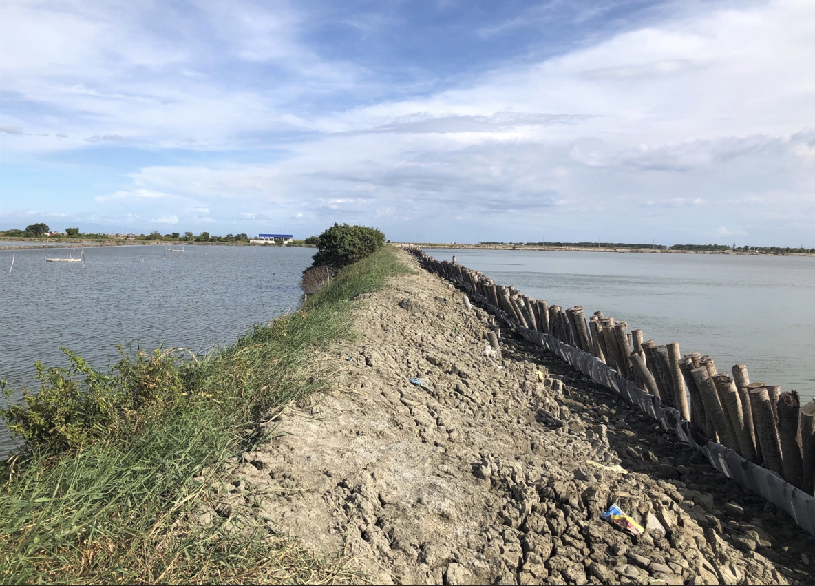
The current practice of constructing embankments and fishpond dikes involves lining relatively steep slopes with concrete. Due to settlement processes and concrete quality issues, these concrete “revetments” disintegrate rapidly, causing high maintenance costs, and pose a flood protection issue as the dikes could fail. By transforming these embankments into ‘green embankments’, the life cycle costs of these embankments will be reduced and, in the meantime, also provide habitat restoration.
Pampanga river outfall widening
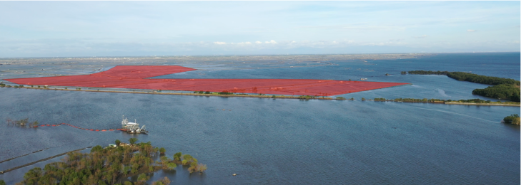
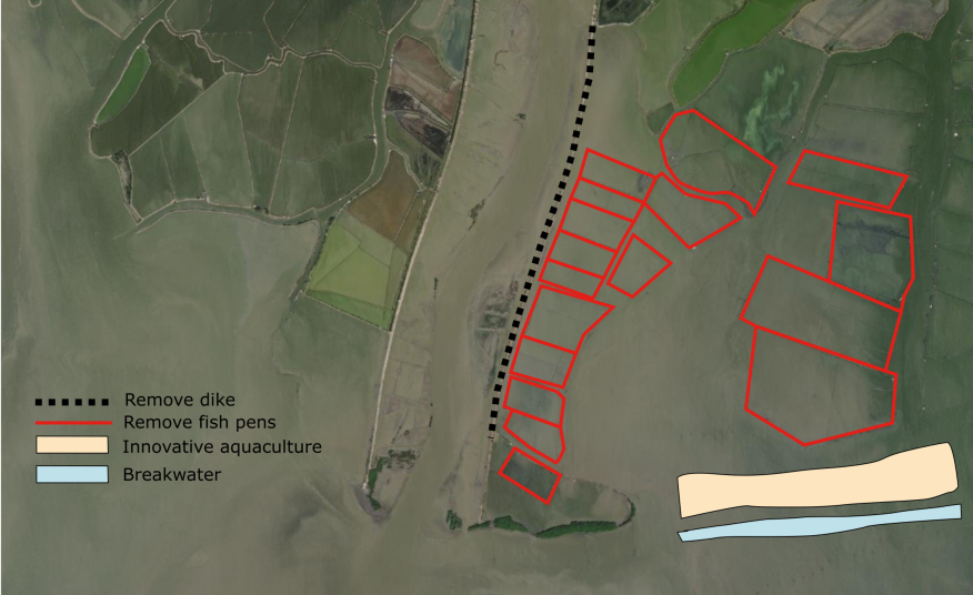
The Pampanga River outfall is a location where various issues related to flood protection, natural habitat restoration and protection of internationally critical habitats for thousands of migratory waterbirds come together. The river has been diked far further than its original outflow. The mudflats and mangrove/coastal forest are transformed into fishponds, and the riverbed and foreshore seabed are being used as sediment mining areas. The pilot aligns with the plans of the Building with Nature Asia Landscape proposition as well as DENR-BMB's ongoing effort to declare the area legally as a Critical Habitat which seeks to restore and protect natural habitats along the North Manila Bay coastline.
Together with the institutional setting, the North Manila Bay Flood Protection Strategy provides the basis to implement these pilots. Either ABB-BP or an LGU may need to use the strategy as a basis to in the short-term to issue a number of legal ordinances and in the longer-term, update the CLUPs and arrange for funding (internally or externally). The provincial, regional, and national government agencies will need to support the LGUs as they should via the existing legal frameworks.
The North Manila Bay Flood Protection Strategy team concludes that the strategy provides the tools needed to develop the North Manila Bay area sustainable towards the future, respecting the various interests of the stakeholders. It may also be a useful tool in coming up with Biodiversity Off-set Plan for the same area as required by the DENR as compliance to develop the new Manila International Airport in Bulacan. It also provides guidance for future strategy implementation within the Philippines for Nature-based Solutions.