Land Subsidence
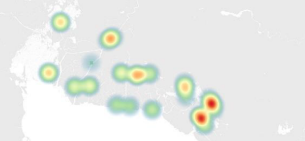
Land subsidence resulting from excessive groundwater extraction is a well-recognized phenomenon in the Philippines today but largely unstudied in the North Manila Bay area, even though land subsidence in many areas contributes to flooding more than the sea level rise. The Manila Bay Sustainable Development Masterplan [1] recognizes this problem and translated some studies into a quantitative assessment shown in the figure below. The red areas indicate a land subsidence rate of 20-50 cm a year and the green areas 7 to 13 cm a year.
The Manila Bay Sustainable Development Masterplan states:
"With the rate of land subsidence plus sea-level rise at the north of Manila Bay, any flood protection measure or development project initiated now are likely to become dysfunctional within the next decades. With the rate of population growth and expansion in these areas, addressing the concerns of communities on being exposed to flooding has become more complicated and difficult to manage."
Groundwater extraction is the major driver for land subsidence in the North Manila Bay Delta. Various literature concluded that even if groundwater use is significantly reduced, the natural deltaic subsidence and global sea-level rise will continue to increase the flooding exposure of the North Manila Bay Delta. As drawn from the figures below, sea-level rise and groundwater extraction peaked over the last decades.
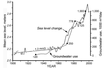
Sea level rise vs. groundwater usage and subsidence in North Manila Bay [26]